Wayanad
Wayanad District, in the north-east of Kerala, was formed on November 1, 1980 as the 12th district, carved out of Kozhikode District and Kannur District. Though the word Wayanad is believed by some to have originated from Vayal (paddy) and Naad (land), 'Land of Paddy Fields', some scholars disagree. The region was known as Mayakshetra (Maya's land) in the earliest records. Mayakshetra evolved into Mayanad and finally to Wayanad. There are many indigenous tribals in this area. It is set high on the majestic Western Ghats with altitudes ranging from 700 to 2100 m. The district is going through its worst agrarian crisis.
Climate
The distance from the mean sea level and surrounding forest creates a salubrious climate. Generally the year is divided into four seasons; cold weather (December to February) hot weather (March to May) South West monsoons (June to September) and North East monsoon (October to November). During the hot weather the temperature goes up to the maximum of 35 °C and during the cold weather the temperature goes down to 10 °C. The more perceived temperature variation in habitational areas since last 5-6 years is in the range of 18-28 degree Celsius. The average rainfall is 2,500 mm per year.
This article is licensed under the GNU Free Documentation License. It uses material from the Wikipedia and numerous other sources that provide freedom to copy and redistribute content, with or without modifying it, either commercially or noncommercially. |


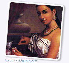 Raja Ravi Varma is most remembered for his paintings of beautiful sari clad women, who were portrayed as very shapely and graceful. His exposure in the west came when he won the first prize in Vienna Art Exhibition in 1873. After a successful career as a painter, Raja Ravi Varma died in (1906) at the age of 58. He is generally considered as one among the greatest painters in the history of Indian art.